Commute time is one of those things buyers think they understand… until they actually start driving it every day. In Colorado Springs, commute patterns are shaped by geography, military installations, growth patterns, and the fact that there is no single “downtown commute” like you’d see in larger metro areas.
Understanding how traffic really flows here can help buyers choose the right neighborhood, set realistic expectations, and avoid daily frustration after move-in.


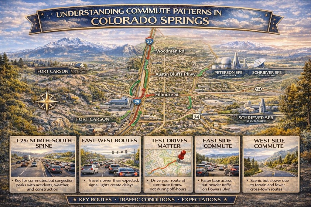
Colorado Springs Is a Multi-Directional Commute City
Unlike cities where most people commute into one central business district, Colorado Springs traffic moves in multiple directions at once.
Major employment centers include:
- Fort Carson
- Peterson Space Force Base
- Schriever Space Force Base
- U.S. Air Force Academy
- Downtown Colorado Springs
Because jobs are spread across the city, traffic patterns depend heavily on where you’re going, not just where you live.
North–South Traffic: I-25 Is the Spine
Interstate 25 is the main north–south artery through Colorado Springs, and it plays a huge role in daily commutes.
Morning traffic typically flows:
- Southbound toward downtown and Fort Carson
- Northbound toward the Air Force Academy and Monument
Afternoons reverse that pattern.
Accidents, weather, or construction on I-25 can ripple quickly across surface streets, which is why proximity to on-ramps matters just as much as distance on a map.
East–West Commutes Are Often Slower Than Expected
East–west travel is where many newcomers are surprised.
Major east–west corridors include:
- Powers Boulevard
- Woodmen Road
- Austin Bluffs Parkway
- Fillmore Street
While these roads are wide, they’re heavily signalized, which means commute times can fluctuate significantly based on time of day.
For example, a drive from the east side to downtown might look short in miles but feel long during peak hours. Conversely, west side residents commuting east often experience bottlenecks at limited crossing points.
East Side Commute Patterns
The east side of Colorado Springs continues to grow rapidly, especially in areas like Banning Lewis Ranch, Wolf Ranch, and Cordera.
Common east side commute realities:
- Faster access to Peterson Space Force Base and Schriever Space Force Base
- Heavier traffic on Powers Boulevard during peak hours
- Longer drives to downtown and west side destinations
Buyers who work on bases or prefer newer infrastructure often accept longer cross-town drives as a trade-off.
West Side Commute Patterns
West side neighborhoods offer proximity to trails, open space, and historic districts, but commute patterns are more constrained.
West side commuters often experience:
- Fewer road options due to terrain and established neighborhoods
- Slower eastbound travel during rush hour
- Faster access to downtown and west side amenities
West side living tends to favor buyers who work downtown, remotely, or have flexible schedules.
Military Schedules Shape Traffic Flow
Military presence heavily influences commute timing. Shift changes, PT hours, and base access points create predictable congestion windows around installations like Fort Carson and Peterson Space Force Base.
PCS season can amplify these patterns, increasing traffic during spring and summer months when relocations peak.
This is one reason commute times in Colorado Springs can feel very different during different parts of the year.
Weather and Terrain Matter
Colorado Springs weather directly impacts commutes.
Snow, ice, and wind affect:
- North-facing roads that hold snow longer
- Elevated areas and foothills neighborhoods
- East side open corridors where wind can reduce visibility
Buyers often underestimate how winter weather can change a “normal” commute, especially when driving from higher elevations or newer developments.
Remote Work Has Changed the Equation
Remote and hybrid work have shifted commute priorities for many buyers.
Instead of focusing on daily drive times, buyers now ask:
- How easy is occasional commuting
- Is the neighborhood convenient for errands and schools
- Are roads manageable during peak times when I do need to drive
This shift has expanded demand across more areas of the city, not just traditionally “central” neighborhoods.
Why Test Drives Matter More Than Maps
One of the biggest mistakes buyers make is relying solely on GPS estimates.
Commute times in Colorado Springs vary significantly by:
- Time of day
- Day of the week
- School schedules
- Military cycles
- Weather conditions
Driving a route at the actual time you’d commute is one of the most valuable steps buyers can take before choosing a neighborhood.
Infrastructure and Future Development
Ongoing road projects and city planning influence commute patterns over time. Resources from the City of Colorado Springs provide insight into planned improvements, expansions, and long-term transportation goals.
New development often brings short-term congestion and long-term improvements, which buyers should factor into decisions.
What Buyers Should Consider
When evaluating commute patterns, it helps to ask:
- Where will I drive most often
- How flexible is my schedule
- How does winter affect this route
- What happens during peak military cycles
There is no universally “best” commute in Colorado Springs. There is only the best fit for your lifestyle.
Final Thoughts
Commute patterns in Colorado Springs are shaped by geography, military presence, and growth, not just distance. Understanding how traffic actually flows can help buyers choose neighborhoods that support their daily routines instead of fighting them.
A home can be perfect, but if the commute doesn’t work, daily life feels harder than it needs to be. Taking the time to understand local traffic patterns upfront leads to better decisions and happier homeowners in the long run.

Leave a comment